|
| China |
| The tallest mountain in the world became taller | |
|
|
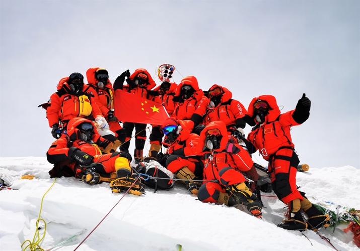 Chinese surveyors take a group photograph after summiting Mount Qomolangma on May 27(XINHUA)
Mount Qomolangma is becoming taller, China and Nepal jointly announced on December 8. It has currently reached 8848.86 meters, setting a new historical record for the height.
Chinese President Xi Jinping and Nepali President Bidya Devi Bhandari announced this result in their exchanged letters. Xi noted that the teams of both countries have overcome various difficulties, carrying out important work and finally determining the new altitude.
In spring 2019, a climbers' team from Nepal summited the mountain to collect data for the purpose of this measurement. It was the first time ever for Nepal to organize such a measuring expedition to the top. In May 2020, a team from China climbed the mountain for further data collection.
Xi said Mount Qomolangma is "an important symbol of the China-Nepal traditional friendship," and the joint announcement shows the high level of the continuously developing bilateral relations.
This year marks the 65th anniversary of the establishment of diplomatic relations between the two countries.
Trips to the top
Mount Qomolangma straddles the China-Nepal border, with the northern part being located in Tibet Autonomous Region in southwest China. Since the founding of the People's Republic of China in 1949, Chinese surveyors have conducted seven rounds of measurements and scientific research on the mount.
In 1960, three Chinese climbers topped the mount from the northern side, the first time ever for mankind to Mount Qomolangma from its northern flanks.
In 1975, China announced the height of the mount measured by the Chinese team for the first time, determining it at 8,848.13 meters. The mission was depicted in a box-office blockbuster in 2019 The Climbers.
Three decades after the 1975 measurement, China conducted another set of measurements in 2005, finding the mountain had shrunk to 8,844.43 meters.
Chen Junyong, a geologist and academician of the Chinese Academy of Sciences, introduced the theory that Mount Qomolangma emerged from the oceans 38 million years ago as a result of the colliding of Eurasian and Indian tectonic plates.
When the plates move, either toward or away from each other, the height of the mountain changes accordingly. As the plates' movements never cease, regular remeasurement of the peak is needed, theoretically, every 10 to 15 years.
In 2015, a 7.9-magnitude earthquake hit Nepal. Scientists from other countries, assuming the earthquake would affect the height of the mountain, then went on to measure its height via various ways, but were unable to strike a consensus. A more professional measurement was thus necessary.
This year marks the 60th anniversary of Chinese mountaineers' first successful expedition to Mount Qomolangma as well as the 45th anniversary of China's first measurement of its height, which adds a sense of great historical importance to the remeasurement, as the Ministry of Natural Resources said on its Sina Weibo account.
The new round of measurements was jointly initiated on April 30 by the Ministry of Natural Resources, Ministry of Foreign Affairs, General Administration of Sport of China and Government of Tibet Autonomous Region. Multiple homegrown technologies were applied in this round, including the BeiDou-3 Navigation Satellite System, Chinese-made surveying equipment, a gravimeter carried by plane, and 3D-interactive virtual reality.
Li Guopeng, captain of the Ministry of Natural Resources' First Geodetic Surveying Brigade, said this survey effectively combined cutting-edge technologies with traditional ones.
The surveyors still follow the principle of basic trigonometry, a traditional technique in measuring the mountain, which requires setting up several checkpoints on the ground as well as measuring the distance between two points and then calculating the angles between the top of the mountain and each point. With one side and two angles of a triangle, they can calculate the lengths of the other sides and get the result of the height of the triangle, which results in the height of the mountain.
Liu Zhanke, deputy chief engineer of this year's survey, said scientists set up six points on the ground.
On May 6, a team of surveyors and mountaineers started out from the North Base Camp in Tibet to scale the peak. After failing twice due to weather changes, on May 27, a team of eight finally reached the summit. They remained there for two and a half hours, setting a new record for Chinese climbers.
They erected a surveyor's beacon, an important measuring device. Once the surveyor's beacon was in place, the surveyors at stations around the summit measured the distance from the six points to the beacon. They additionally installed an antenna for the Beidou Navigation Satellite System on the snow-covered peak.
In addition, the team members also conducted a global navigation satellite system survey, snow depth measurements, as well as a gravity survey at the summit.
After collecting the measurement data, reportedly amounting to 1trillionbyte, scientists spent many months using multiple traditional and modern measurement techniques to process and analyze them, performing calculations and eliminating errors induced by factors such as temperature, air pressure and the refractive environment.
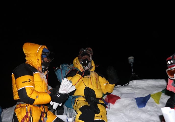 Nepali surveyors atop Mount Qomolangma in May 2019(XINHUA)
Cooperation and commitment
After the new height was announced, Khim Lal Gautam, who climbed Mount Qomolangma in May 2019, is very happy to see both countries endorsing the newly established height together. In an interview with Xinhua News Agency, he hailed the fact that technical teams from both countries sat together sharing their data and information as "an example of technical collaboration between the two countries."
Xi said China is willing to work with Nepal to promote cooperation in the environmental protection of and scientific research on Mount Qomolangma.
"Being open and sharing is the important principle for China's development of science and technology, the cooperation of China and Nepal in conducting this measurement is a vivid example thereof," Guo Yanjun, a professor at China Foreign Affairs University, said.
China and Nepal have engaged in cooperation far beyond the measurement of the mount.
Nepal and China have always been good neighbors, friends and partners, Bhandari in her letter said. Cooperation in areas of economic development, connectivity, and cultural and people-to-people exchanges is in line with both countries' interests, she added.
Moreover, China's emphasis on raising the ecological protection levels in the Qomolangma area conveys the message of China's long-time commitment to sustainable development, Guo added. "It is also a promise China has made to Nepal and the world in the context of climate change," Guo concluded.
(Print Edition Title: A New Height)
Copyedited by Elsbeth van Paridon
Comments to yuanyuan@bjreview.com
|
|
||||||||||||||||||||||||||||||
|