|
||||||
| Home Nation World Business Opinion Lifestyle Multimedia Documents Special Reports Africa Travel |
|
||||||
| Home Nation World Business Opinion Lifestyle Multimedia Documents Special Reports Africa Travel |
| Nation |
| China Releases Images Captured by HD Earth Observation Satellite | ||
| The nation's most sophisticated observation satellite is in good condition and capturing stable images | ||
| Edited by Chen Ran | ||
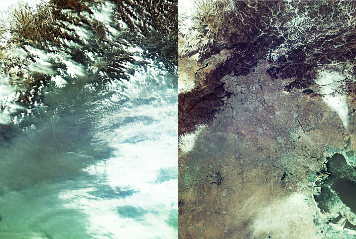
China released first images captured by the nation's most sophisticated observation satellite Gaofen-4 on Wednesday, including one showing the capital city Beijing amid heavy smog. Each of the images, released by the State Administration of Science, Technology and Industry for National Defense (SASTIND), covers an area of at least 400 km, said Tong Xudong, chief designer of the Gaofen project with SASTIND. One image taken on January 21 showed Beijing and neighboring areas were covered by heavy smog while another clear image of the same region was taken on January 25, when the smog dispersed. Other images feature Nam Co in Tibet Autonomous Region, the world's highest saltwater lake, the Yellow River delta and a forest fire in south Australia. The Gaofen-4 satellite was launched on December 29, 2015 as China's first geosynchronous orbit HD optical imaging satellite. Currently, it is in good condition and capturing stable images, according to the SASTIND. It is orbiting 36,000 kilometers away from earth, but can still find objects as small as an oil tanker on ocean using its huge CMOS camera, reaching the best imaging level among global high-orbit remote sensing satellites. The Gaofen project aims to launch seven high-definition observation satellites before 2020, designed for disaster prevention, surveillance of geological disasters and forest disasters and weather forecast. Gaofen-1, the first satellite of the project, was launched in April 2013. China plans to launch the Gaofen-3 satellite in 2016, Tong said. (Xinhua News Agency February 3, 2016) |
About Us | Contact Us | Advertise with Us | Subscribe
|
||
| Copyright Beijing Review All rights reserved 京ICP备08005356号 京公网安备110102005860号 |