|
||||||
| Home Nation World Business Opinion Lifestyle China Focus ChinAfrica Multimedia Columnists Documents Special Reports |
|
||||||
| Home Nation World Business Opinion Lifestyle China Focus ChinAfrica Multimedia Columnists Documents Special Reports |
| Nation |
| Reaching New Heights |
| An indigenous satellite system provides global services |
| By Lu Yan · 2019-01-15 · Source: NO. 3 JANUARY 17, 2019 |
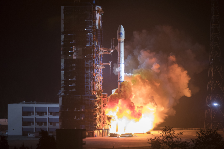 The 42nd and 43rd BeiDou satellites are launched from the Xichang Satellite Launch Center in Sichuan Province on November 19, 2018 (XINHUA)
The morning commute in rush hour traffic and finding a suitable parking spot can be an arduous task, but thanks to the BeiDou Navigation Satellite System (BDS), a homegrown navigation satellite system, things have become a little easier for commuters in Xi'an, capital of northwest China's Shaanxi Province. The system can trace vehicles which have the electronic chip installed and guide them to the nearest available parking space with a high degree of accuracy. In the future, the BDS will play a larger role in both regional and national road planning and congestion remission. Currently, the system covers 400 Chinese cities. Since December 2018, China's BDS has provided global services, said BDS spokesperson Ran Chengqi at a press conference on December 27, 2018. As coverage grows, it is expected to constantly improve and become more convenient for users worldwide. At the conference, Ran announced that by 2020, with the launching of another 11 BeiDou-3 and one BeiDou-2 satellites, the construction of the BDS will be completed and its performance will be further improved. By 2035, a ubiquitous, integrated and intelligent comprehensive positioning, navigation and time service with the BDS as its core will be fully established. "From now on, BeiDou will always be there for you, no matter where you go," Ran said.  A marine research operation is carried out by Chinese scientists based on the BeiDou Navigation Satellite System on December 4, 2018 (XINHUA)
Developing the BDS The BDS is a satellite navigation system developed and operated by China. Now available worldwide, the BDS is now the fourth global satellite navigation system after the U.S. Global Positioning System (GPS), Russia's Global Navigation Satellite System (GLONASS) and the European Union's Galileo. The BDS is also compatible with the other three. The construction of the BDS can be traced back more than two decades. In 1994, the China National Space Administration initiated the plan to independently develop the BDS. In December 2000, the BeiDou Navigation Satellite Demonstration System, also known as the BeiDou-1, was built, making China the third country to have an independently developed navigation satellite system after the United States and Russia. Twelve years later, the BeiDou-2 was operational, providing positioning, navigation, timing, speed measurement and short message communicating services for domestic customers and also those in the wider Asia-Pacific region. BeiDou-3, the latest generation of the BDS, started its satellite constellation in November 2017. Since then, China has sent 19 BeiDou-3 satellites to space over 10 launches, completing the basic system construction. The service for global users has also been achieved ahead schedule, initially planned for 2020 as stated in a white paper on the BDS released by the State Council, China's cabinet, in June 2016. "This marks the fastest satellite navigation system construction in the world," Ran said. Civil application In addition to road and traffic planning, the BDS is playing an increasingly important role in other areas of urban construction. With its clock synchronization and positioning, the system is applied to gas networks, heating supply systems, electricity grids, water supplies and drainage engineering, building deformation, and engineer operations. Ancient cities can use the system to protect cultural relics and historical sites. The Shaanxi Provincial Cultural Heritage Administration installed the BDS terminal near the cultural relics in order to help manage them. It uses satellite remote sensing technology to monitor the natural condition and human activities at the historical sites. The BDS has helped make cities smarter, safer and more efficient. Currently, China is working on a national public security system using the BDS terminal and other relevant systems. When emergencies occur, the police can act quickly to command and dispatch resources to crack down on crimes or respond to citizens' requirements. Police officers in Jiangbei District in southwest China's Chongqing Municipality, among other Chinese cities, are equipped with a mobile device with an app backed by the BDS. Using the app, police officers can record data online, have access to surveillance videos and search motor vehicles and drivers' information. There are also significant benefits for farmers. Yang Guoliang is a farmer living in Tiantai County in east China's Zhejiang Province. In 2018, he expanded his rice planting area to over 113 hectares. One of the reasons was that he installed BDS terminal equipment on his rice transplanter. The equipment can trace the movement of the transplanter and calculate the total field he owns. "Before I used the BDS terminal, merely calculating the total field area took a great deal of time and energy. Farming is now much easier for me," Yang told Taizhou Daily. "The BDS is very handy for big farming households, the data is generated automatically, and it is very accurate," said Ying Yongfu, head of the farm machinery management station in Tiantai. The BDS is playing a role in all walks of life, for instance, on smart phone apps, vehicle navigation system or wearable devices. Through deep integration with information communication, Internet of Things and cloud computing, the system offers location based services and makes life more convenient. According to Ran's report delivered at the Ninth China Satellite Navigation Conference in May 2018, China's industrial output value of domestic satellite navigation reached 255 billion yuan ($37 billion). This is 20.4 percent above the previous year and its industry scale is expected to exceed 400 billion yuan ($58 billion) in 2020. Global services The BDS is not only a crucial element of national infrastructure, but also a global resource. It now covers nearly 30 countries along Belt and Road routes. In Mongolia, herders can use the BDS to track the amount, location and state of livestock in the cold winter; Laotian farmers use it on precision farming and pest and disease control; a BDS data and service center located in Malaysia is providing services for users in ASEAN countries. The BDS has already been recognized by international organizations such as the International Civil Aviation Organization, the International Maritime Organization and the Third-Generation Mobile Communication Standard Partnership Project. In the future, it will offer free search and rescue services worldwide. The system also established a cooperative mechanism with GPS in 2014 for an improved civilian service. It has conducted cooperative work with Galileo and GLONASS in 2015 and 2017, respectively. "We hope that through cooperation between systems, we can each promote our own advancement," Ran said. Copyedited by Craig Crowther Comments to luyan@bjreview.com |
About Us | Contact Us | Advertise with Us | Subscribe
|
||
| Copyright Beijing Review All rights reserved 京ICP备08005356号 京公网安备110102005860号 |