|
 |
|
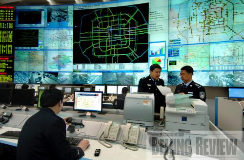
HI-TECH CONTROL: Beijing's Traffic Management Bureau Command Center has been monitoring and directing Beijing's road traffic since it started operating in April 2007 (LIU YINGYI) |
The National Day parade marking the 60th anniversary of the founding of the People's Republic of China happened on Beijing's central Tiananmen Square on October 1. The event drew an audience of more than 200,000 people and nearly 200,000 participants, who all needed to be dispersed within three and a half hours after the ceremony. The event posed an unprecedented challenge to the city's traffic control system.
But a newly adopted intelligent transportation system (ITS), which uses information and communications technologies to manage infrastructure and vehicles, helped the Beijing Traffic Management Bureau complete its daunting mission.
The bureau mobilized 7,000 traffic police officers and 6,000 traffic coordinators to work throughout the city that day, all of whom were equipped with global positioning system receivers, said Sui Yagang, vice director of the bureau. The tool enabled data and video communications between the bureau's command center and parade organizers.
The command center, put into operation on April 28, 2007, possesses the largest and most advanced ITS in the world. It is equipped with 22 live monitoring systems that provide traffic videos and information on signals and the flow of vehicles. The system, which covers the whole city and operates around the clock, also monitors accidents and immediately reports them to the police.
The parade and colorfully decorated Tiananmen Square made Beijing a popular tourist destination during the one-week National Day holiday. The city received 14.97 million visitors during the holiday, up 59 percent year on year, according to statistics from the Beijing Tourism Administration.
To cope with the surge of pedestrians and vehicles during the holiday, all of the 277 information screens along Beijing's vehicular arteries that carry real-time traffic information were activated so that drivers could try to avoid congested streets. Traffic cameras operated at full capacity to catch all traffic violations.
 |
|
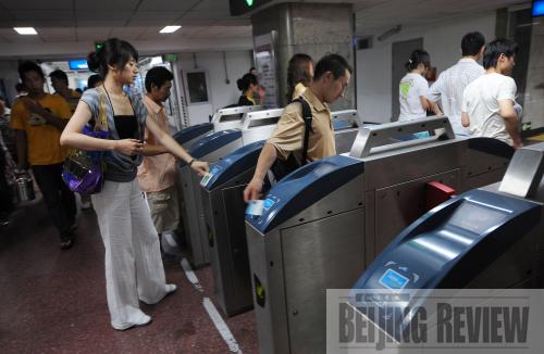
SMART CARDS: Transit cards used by Beijing subway passengers help authorities accurately record and monitor the flow of riders (JIANGHONGJING) | Beijing is home to 3.85 million vehicles and sees around 1,500 new ones every day. With such a growth rate and with the city's population reaching 16 million, it will not be long before the capital sees 4 million vehicles on its streets. Li Xiaosong, a Beijing Municipal Committee of Transport spokeswoman, said that Beijing's traffic infrastructure has been able to sustain the city's normal operation and that economic and social development can be partly attributed to the use of the new technologies.
"The city has more than 20,000 buses, probably the largest municipal bus fleet in the world. They are all efficiently coordinated by an intelligent bus assignment system," she said.
Complete control
Several kinds of ITS information are being transmitted to the command center of the city's traffic management bureau, the system's brain.
"We have a digital map with different colors symbolizing different traffic situations, with red representing congestion and yellow marking locations of slow traffic. The on-road monitoring system updates the map every two minutes," said Zhang Chenjun, vice director of the command center, who was standing in front of the huge screen that displayed the map.
|