| The Sino-Japanese dispute over the sovereignty of the Diaoyu Island Chain has become increasingly pronounced in recent weeks due to provocative acts perpetrated by Japanese right-wingers who illegally constructed various facilities, including a lighthouse, on Diaoyu Island, the main island. This article discusses the ownership of sovereignty over the islands from both historical and legal perspectives.
Historical evidence
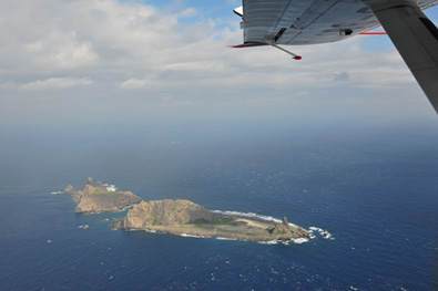
Diaoyu Island and adjacent islets in the chain are located 92 nautical miles northeast of Keelung, China's Taiwan Province, and 73 nautical miles off Japan's Ryukyu Islands. Keelung and Ryukyu are separated by a deep oceanic trench. The Diaoyu Island Chain covers a total land mass of 6.3 square km and consists of Diaoyu Island, Huangwei, Chiwei and South and North islets and three small reefs. Diaoyu Island, the largest land mass in the chain, covers 4.3 square meters and rises to elevation of 362 meters above sea level. The southeastern shores of the island feature sharp and steep precipices which remind one of the shape of fork, while formations on eastern shores resemble a lighthouse. The islands have remained uninhabited due to a lack of fresh water.
Chinese documents referring to the Diaoyu Island Chain date back to the Ming Dynasty (1368-1644). Although Japan claims that the chain was under the jurisdiction of Okinawa-Ken (Okinawa Prefecture) in ancient times, the fact is that present-day Okinawa was part of the independent Ryukyu Kingdom a short 125 years ago. China maintained friendly ties with the Ryukyu Kingdom for over 500 years prior to the Japanese annexation of same in 1871. In fact, China discovered and named the islands, with the name Diaoyu Island first appearing in 1403 in a book entitled Shunfeng Xiangsong (Smooth Sailing).
China first appointed imperial envoys to the Ryukyu Kingdom in the 1360s. In 1534, Chen Kan, the 11th envoy to the kingdom, described his voyage to the kingdom with Ryukyu envoys in a book entitled Observations on a Voyage to Ryukyu. He wrote: "A brisk southerly wind on the 10th day of the voyage propelled the ship forward. We sailed past Pingjia Mountain, then Diaoyu Island, Huangmao Island and Chiyu Islet, using only one day to cover a distance which would have normally required three days. The Ryukyu boats lagged far behind due to their smaller sails. Komeyama Island (now Japan's Kome-jima) in the Ryukyu Kingdom appeared on the horizon on the evening of the 11th day, with ecstatic Ryukyu envoys singing and dancing out of joy over at long last seeing their home."
The passage quite obviously indicates that even people in ancient Ryukyu regarded their home as an island far distant from the Diaoyu Island Chain. The fact is that Diaoyu, Huangwei and Chiwei islands did not belong to the Ryukyu Kingdom at the time.
Moreover, a nautical map compiled by Zhejiang Provincial Commander Hu Zongxian in 1562 during the Ming Dynasty shows Diaoyu Island and adjacent islets in close proximity to other islands on the coast of Luoyuan and Ningde Counties in Fujian Province. This fact proves that Diaoyu Island was listed as Chinese territory in the 16th century.
Imperial envoy Guo Rulin also penned similar observations in his notes. Guo's notes read: "On the first of May (lunar calendar), we passed Diaoyu Island, and on the third arrived at Chiyu Islet, the dividing line with Ryukyu. A day later we arrived at Komeyama."
This passage clearly demonstrates that China already used Chiyu Islet (present-day Chiwei Islet), the chain's closest islet to Ryukyu, as a marker delineating the boundary between them.
Chinese sailors during the Qing Dynasty (1644-1911) were very familiar with the fact that a deep oceanic trench to the south of Diaoyu separated Ryukyu and China. Shi Wangji, the second Qing Dynasty envoy to Ryukyu, confirmed the existence of the trench in his Miscellaneous Observations on a Voyage to Ryukyu. Volume V of the work describes a trip to Ryukyu in 1683. It notes that sailors held a sacrificial rite to pray for safety after passing the Diaoyu and Chiwei islands. The sailors informed Shi that the ship was passing over the trench which separated China and Ryukyu.
Similar documentation can be found in another book entitled A Brief Introduction to the Kingdom of Ryukyu, written by Zhou Huang who visited the island kingdom in 1756. Volume XVI confirms that the islands west of the trench at Chiwei Island were Chinese territory.
In 1719, during the reign of Emperor Kangxi of the Qing Dynasty, another imperial envoy Xu Baoguang was sent to Ryukyu. Xu completed a book entitled Zhongshan Chuanxin Lu (The Record of Zhongshan) after having conducted thorough research, including interviews with local geographers and officials. The book was well organized and supported. It was translated into Japanese and became an important source of information for the Japanese people to understand the Ryukyus.
Xu described his sea route from Fuzhou of China's Fujian Province to the Ryukyus as follows: proceeding along the north side of the islands Huaping, Pengjia and Diaoyu, reaching Komeyama Island via Chiwei Islet. The book notes that Komeyama is the mountain serving to guard the southwest border of the Ryukyus and that the Yonakuni Island, among current Japan's Yaeyama Islands, is that border.
All these documents show that both the courts of the Ming and Qing dynasties designated the Diaoyu Island Chain as Chinese territory. In October 1893, prior to the Sino-Japanese War of 1894-95, Empress Dowager Cixi issued an edict presenting the islands to Sheng Xuanhuai, then Qing Minister of Posts and Communications, as his possession for gathering medicinal herbs. The edict says, "Sheng Xuanhuai once contributed pills which are very effective. He reported that the medicinal herbs are produced in the Diaoyutai Island beyond Taiwan and show unique effects different from those produced on the mainland. It is commendable that the minister operates some drugstores to offer medical treatment to the public. Therefore, the islands of Diaoyutai, Huangwei and Chiyu are hereby given to Sheng Xuanhuai as his estates for gathering medicinal herbs."
Japanese historians also share the position of the Chinese government that Diaoyu Islands have been Chinese territory since the Ming Dynasty. Well-known Japanese historian Kiyoshi Inoue, through serious textual research, came to the conclusion in his book Historical Analysis of Senkaku-Diaoyu Islands, published in 1972, that Diaoyu Islands "were not an unclaimed land before Japan laid claim to it". After years of consulting historical records, he concluded that Diaoyu Islands were Chinese territory. The scholar said in the book that "before 1868 there was virtually no documents in Japan or Ryukyu which carried any record of Diaoyu Islands, other than Chinese documents."
|