|
| China |
| In its 50th year, Fengyun meteorological satellite program plays a global role | |
|
|
|
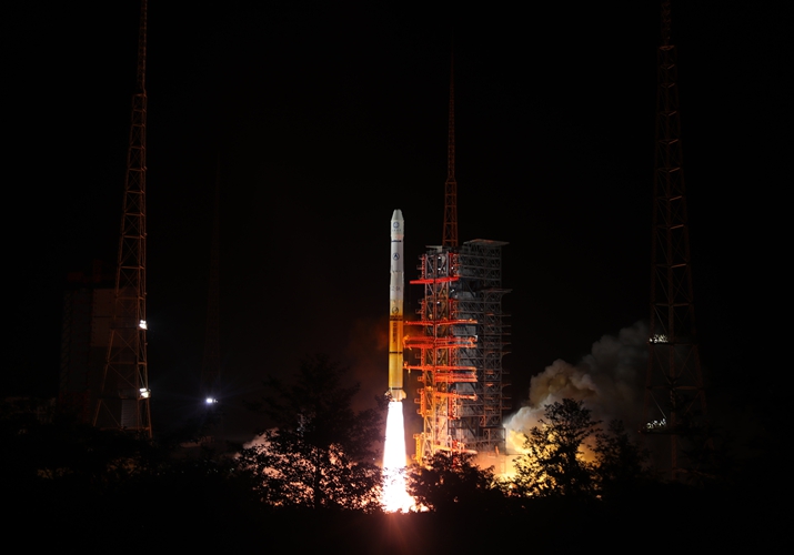
The Fengyun-2H satellite is launched on a Long March-3A rocket from the Xichang Satellite Launch Center in Sichuan Province, southwest China, on June 5, 2018 (XINHUA) Professor Xu Jianmin is a proud man today. The academician of the Chinese Academy of Engineering is celebrating the 50th anniversary of the Fengyun meteorological satellite program as the designer of its general ground system architecture. Over the five decades, the program launched 17 satellites in space, seven of which are in orbit today. The data they provide have improved global weather forecasting and helped diverse sectors like ocean, agriculture and ecology. In an interview to mark the 50th anniversary, Xu told China Meteorological News that the satellite data is used by more than 100 countries or territories, making significant contributions to international disaster prevention and mitigation, climate monitoring and protection of life. The Fengyun satellites are an important space infrastructure for China and a symbol of the modernization of the country's meteorology, Premier Li Keqiang said at a symposium on October 10 to mark the 50th anniversary.
A visitor views a model of the Fengyun-4 satellite at the 2019 China International Industry Fair in Shanghai on September 17, 2019 (XINHUA) The genesis Fengyun means wind and cloud in Chinese. Work on the first meteorological satellite in this series started in November 1977 and Fengyun-1A was launched 11 years later. However, due to altitude control problems, it disappeared after 39 days. Some satellites launched later on also encountered technical issues but they provided valuable lessons for scientists and engineers. For instance, Fengyun-3A launched in 2008 represented an upgrade in China's polar-orbiting meteorological satellite, signifying the technology had entered the world's advanced ranks. The Fengyun-4A satellite, a geostationary satellite launched in 2016, features world-leading technology. It carries a payload that can make high-precision observation of the atmosphere over China and neighboring region, and other advanced devices including radiometers and detecting instruments. It can capture lightning images with its imager. In addition to enhanced imagery scanning capability, the satellite also has an extended lifespan. The satellite system and its applications have been developed entirely through independent innovation. "Behind the brilliance of Fengyun satellites is the hard work of thousands of scientific and technological workers in our country," Yang Jun, chief designer of the Fengyun Meteorological Satellite Project and Director General of the National Satellite Meteorological Center, told Xinhua News Agency. As the chief engineer of the Fengyun-2 Geostationary Meteorological Satellite Space Project, Sun Jiadong has witnessed the development of the national meteorological satellite program since the 1970s. "We faced a number of difficulties at the beginning due to limited technical level and poor conditions," Sun, then 89, told China Space News in an interview. However, it was through numerous trials and errors that the program has made solid progress step by step. He was delighted at how it has changed people's lives and work. Serving the people Typhoon Maria that landed on Fujian Province in southeast China in 2018 is an example. The Fengyun satellite data forecast the typhoon's 24-hour path and intensity with greater precision, helping in providing early warning that protected lives and property. Tang Shihao, deputy chief designer of the Fengyun Meteorological Satellite Project, said the satellites play an irreplaceable role in typhoon monitoring. The Fengyun-2 satellites had monitored 566 typhoons in the Western Pacific and 165 typhoons that had landed in China by August this year. Fengyun-4A is one of the most advanced weather satellites in China, monitoring the weather once every 15 minutes. If necessary, it can conduct local regional monitoring once every 5 minutes. It has reduced the average error in 24-hour typhoon path forecasts from 95 km to 71 km, reaching global advanced level. The Fengyun-3 polar-orbiting satellite inspects major river basins and lakes six times a day to provide data support for weather forecasts, as well as decision-making on flood fighting and rescue. In June, south China suffered severe floods, as the average rainfall along the Yangtze River reached the highest level since 1961. The Fengyun satellites closely followed key water bodies and provided a scientific and reliable basis for rescue and disaster relief. The satellites are also used to monitor natural disasters such as fires, playing an important role in disaster prevention. Equipped with infrared imaging equipment, the satellites can quickly detect forest and grassland fires. In March, a forest fire ravaged parts of Liangshan Yi Prefecture in Sichuan Province in southwest China. Satellites were used to monitor the fire in the remote mountains, providing information for firefighting and early warning. The Fengyun satellite ecological remote sensing services also play an outstanding role in ecological protection. The satellites can comprehensively monitor the Earth environment, enabling accurate understanding of environment changes and providing services for sustainable economic and social development. For instance, the vegetation images captured by Fengyun-3 show that in 2018, north China became greener than in 2000, demonstrating the achievements of afforestation efforts. The satellite data and products are widely used in diverse industries, from marine, agriculture and forestry to transportation and aviation. The China Meteorological Administration (CMA) provides massive data for various industries every day through various means such as satellite broadcasting and the Internet. There are more than 2,700 domestic users in nearly 100 industries who receive and use the data. Going global The Fengyun satellites also contribute to global weather observation and disaster preparedness. The satellite data and products are provided to 115 countries and regions. Personnel from over 100 countries have received special training on Fengyun satellite applications. In 2019, CMA provided satellite services to Mozambique to cope with floods triggered by the tropical cyclone Idai. This year, the World Meteorological Organization listed Fengyun monitoring products as one of the major tools for strengthening monitoring of meteorological hazards, like floods in Iran, desert locust invasion in Pakistan, and cyclonic storms in the Bay of Bengal. "The Fengyun satellites will play a greater role in building an international meteorological disaster prevention, mitigation and relief system, and a community with a shared future for humanity," Yang said. (Print Edition Title: Weathervane in the Sky) Copyedited by Sudeshna Sarkar Comments to luyan@bjreview.com |
|
||||||||||||||||||||||||||||||
|