|
| Editor's Choice |
| The Sky's the Start | |
| BeiDou boosts world navigation system | |
|
|
|
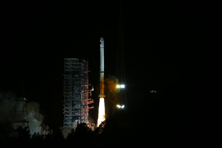
The 22nd BeiDou satellite is launched from the Xichang Satellite Launch Center in Sichuan Province on March 30 (XINHUA) The excitement in the room is palpable and expectations run high. So does the tension. All eyes are on the monitor as the clock ticks away, each second taking viewers toward the denouement. Then it happens. The carrier rocket blasts off into space from the Xichang Satellite Launch Center in southwest China's Sichuan Province, launching with precision a navigation satellite into space. The time is 4:11 a.m., the date March 30, 2016. The satellite is a part of the BeiDou Navigation Satellite System (BDS), China's indigenously developed navigation satellite system capable of providing positioning, navigation and timing services on a continuous worldwide basis, like the American Global Positioning System (GPS), the Russian Global Navigation Satellite System and the European Galileo. "BeiDou is China's as well as the whole world's," said Yang Yuanxi, former Executive Chairman of the China Satellite Navigation Conference Scientific Committee. "It will make global satellite navigation more precise, stable and reliable." How it began China started developing the BDS independently in 1994. In 2000, it became the third country after the United States and Russia to have an independently developed navigation satellite system. The BDS is compatible with the American GPS. A receiver can receive signals from both. The work was planned in three phases. Step one meant starting to build an experimental navigation system in 1994 so that it would provide regional active locating services in six years. The next step was to construct a regional navigation system from 2004 to cover China and neighboring regions. The system was planned to be able to offer passive locating services to the region in eight years. Active locating requires ground stations which transmit satellite signals to users and calculate users' location. Passive locating does not need ground stations. Now the final step is to develop a global navigation satellite system by 2020 that will provide passive locating services. The BDS will be a stable system comprising 35 satellites that will provide reliable service and cover the entire world. By 2020, cellphones and navigation terminal devices all over the world will be able to receive signals from the BeiDou satellites. The BDS test run started in 2011 and one year later, it began to serve customers in the Asia-Pacific region, according to Ran Chengqi, BDS spokesperson and Director of the China Satellite Navigation Office. It covers the area from Iran in the west to the Midway Islands in the east, and from New Zealand in the south to Russia in the north. Since 2012, after the BDS was officially put into service, it is being used by several Asian countries such as Thailand, Malaysia and Indonesia. Thailand's Ministry of Science and Technology has signed cooperation projects with Chinese companies with an initial investment of 3 billion yuan ($476.19 million). Many countries along the Silk Road Economic Belt and the 21st-Century Maritime Silk Road are now seeking BDS-related cooperation. "The BDS will provide service to the world," said Yang Hui, chief designer of the system.
Tan Shusen (center), an academician with the Chinese Academy of Engineering, talks to colleagues in October 2013 (XINHUA) Satellite services Yang said it must be ensured that the service is stable and continuous. "If we disappoint a user once, the user will no longer trust us. While developing the system, we should always keep users' needs in mind." The newly launched satellite, which makes the system more stable, has some new features. Yang said it is not a mere duplicate of any previous satellite but is an upgraded version. Some of its 278 components have been newly developed, some have been upgraded. Over 90 percent of them have been made domestically, including the core units. Moreover, it can adjust its position better. The BDS uses fewer geostationary satellites than its foreign counterparts. In 1983, Chen Fangyun, an aerospace measurement and control expert, said it was feasible to carry out satellite positioning with just two geostationary satellites. The first BeiDou satellite, sent into orbit in 2000, used two geostationary satellites to provide location services to China and neighboring areas. The other difference was that it used active locating while the U.S. and Russian systems use passive locating. The BDS allows two-way positioning, meaning while its user can determine his or her location, others can also track the user's location. It also enables two-way text messaging. A user can transmit messages both to other users and to the control system. The communication function is especially useful in remote areas such as deserts or oceans where cellphone services are unavailable. The BDS is applied in surveying and mapping, in power supply services, water conservancy and fishery. It is used in finance, meteorological and hydrological telemetry. But perhaps its most valuable services are in the fields of security and rescue operations: for public safety, forest fire prevention and disaster reduction and relief. In May 2008, when an 8.0-magnitude earthquake struck Wenchuan, a county in Sichuan, BeiDou devices were used to help rescue teams reach the stricken areas and transmit information outside. The service was especially invaluable as the quake had destroyed the local telecommunication infrastructure. "The BDS can provide location, speed and time information at any time to any place in the world. It can be widely applied in military and civilian sectors, significantly promoting social and economic development," said Zhang Shengyong, an engineer with the research and development center of Shanxi BeiDou Positioning Wave Science and Technology.
BeiDou in boardroom According to a report by CI Consulting, a Chinese investment consultancy, currently, over 13,000 companies in China are in the BeiDou industry, which employs nearly 400,000 people. More than 20 of these companies are publicly listed. With the BDS scheduled to cover the whole world, the industry's prospects are bright. It will attract more companies and investment, the report said. The Chinese Government supported the satellite navigation industry with favorable policies during the 12th Five-Year Plan (2011-15) period. As a result, the industry grew at an annual average of 30 percent in that period, said Miao Qianjun, Executive Vice President and Secretary General of Global Navigation Satellite System and Labs Association of China (GLAC). Miao said last year, the Chinese satellite navigation and location service industry's output reached 200 billion yuan ($30.77 billion). A long-term plan for the industry, released by the government in September 2013, predicted that by 2020, it would exceed 400 billion yuan ($61.54 billion). Among the 100 key projects mentioned in the 13th Five-Year Plan (2016-20), 36 are related to the commercial application of the BDS and remote-sensing satellites. Around 2004, the BDS began to be applied in the military. However, civilian usage has since outpaced it. A recent GLAC report says military usage accounts for only 4.08 percent of BDS applications. "More than 95 percent of BDS users will be in the civilian sector," said Sun Jiadong, BDS's general designer, also known as the father of China's satellite technology. In the civilian sector, both companies and individuals are using the BDS. Satellite navigation and location technology, if combined with other advanced technologies such as geographic information system, the Internet of Things and big data, would be able to provide more comprehensive services. That is seen as the main development direction of the satellite navigation industry. The benefits of BDS services have begun to show. For instance, after the Xinjiang Production and Construction Corps, a unique economic and paramilitary government organization in Xinjiang Uygur Autonomous Region in northwest China, began using farming machines with satellite navigation devices, the land coverage rate increased by 5 percent. After using the BDS, Tianjin Port in north China saw its container operations became 100 percent accurate. It resulted in operation costs being slashed by 20 percent. The BDS is being more and more widely used in people's daily life, with BeiDou chips installed in cellphones and electric bicycles. The technology is also being used to provide care for the elderly. "To have a future, the satellite navigation industry must develop technology and terminal devices to be used in mass consumer products," Yang said. "China has 900 million cellphones in service. If every cellphone is equipped with BeiDou devices, how big the industry would be!"
Driven by Innovation Shanxi, a coal-rich province in north China, sees a large traffic of coal-transporting vehicles. Shanxi BeiDou Positioning Wave Science and Technology developed satellite navigation terminals for vehicles in 2012 and today, Shanxi's coal-shipping vehicles are equipped with them. It reduces chances of theft and facilitates relief operations in case of accidents. In the same year, the Ministry of Transport ordered inter-city buses, chartered buses and vehicles shipping dangerous goods to install satellite navigation terminals. The safety measure has created a great opportunity for the commercial utilization of the BDS. The Frequency Finder At 74, Tan Shusen looks back on the mission he had undertaken more than two decades ago. It was 1994 and China had made the decision to independently develop the navigation satellite system. Tan left his surveying and mapping job, where he had spent 29 years, to be the deputy chief engineer at the ground system of the first-generation BeiDou Navigation Satellite System (BDS). The United States had already completed its Global Positioning System with a constellation of 24 satellites covering 98 percent of Earth's surface and Russia was constructing its own system. One of Tan's major contributions to the BDS is negotiating and obtaining the frequencies the system can use. Frequencies are valuable non-renewable resources for navigation satellite systems. Over the years, Tan and his team have participated in hundreds of negotiations with dozens of countries, clearing obstacles for the BDS. He has creatively proved that navigation satellites can use overlapping frequencies, which has met with international consensus. Tan was elected to the Chinese Academy of Engineering in 2015. Copyedited by Sudeshna Sarkar Comments to tangyuankai@bjreview.com |
|
||||||||||||||||||||||||||||||
|