|
| Editor's Choice |
| Completion of BeiDou Navigation Satellite System signals greater opportunities for cooperation and development | |
| After traveling for a week, the final satellite in the BeiDou family reaches its intended geostationary orbit on June 30 | |
|
|
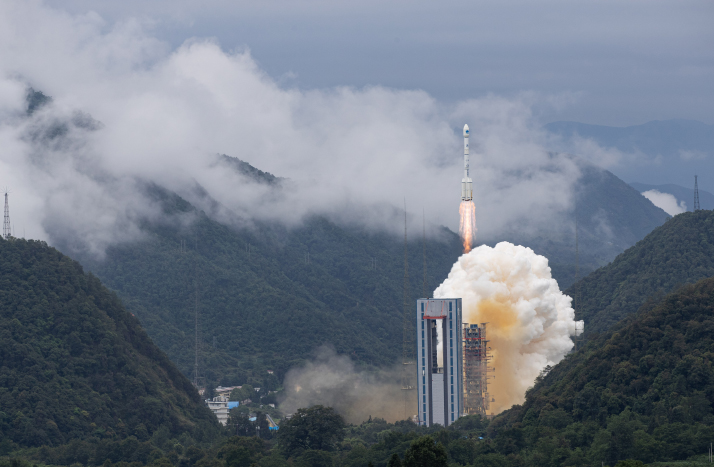 The 55th and final satellite to complete the third-generation network of the BeiDou Navigation Satellite System is launched from the Xichang Satellite Launch Center in Sichuan Province, southwest China, on June 23 (XINHUA)
After traveling for a week, the final satellite in the BeiDou family reached its intended geostationary orbit on June 30. The 55th one in the constellation, it finally completed the BeiDou Navigation Satellite System (BDS). The satellite's payloads and other systems are working normally, the China Aerospace Science and Technology Corporation announced on that day. The launch on June 23 was watched keenly by people at home and abroad. The UN Office for Outer Space Affairs (UNOOSA) extended congratulations to China on the completion of the BDS constellation. "Today, we mark the end of a long journey. Initiated in 1994, the BeiDou program has been over 25 years in the making. This result is only possible with a long-standing and sustained commitment to space," Simonetta Di Pippo, Director of UNOOSA, said. She called the launch a "historic milestone" and "a significant step toward increasing the availability of precise geolocation services through global navigation satellite systems for people all over the world." BeiDou is the Chinese name for the group of seven stars known as the Big Dipper, located in the Ursa Major constellation. In ancient China, people used to navigate following the Big Dipper. Besides the United States' GPS or Global Positioning System, Russia's GLONASS and the European Union's Galileo, the BDS is the fourth global navigation network in the billion-dollar market for geolocation services. It is the first global navigation system from Asia.  A smart tractor equipped with a BeiDou Navigation Satellite System terminal plows a field in Qingdao, Shandong Province in east China, on March 12 (XINHUA)
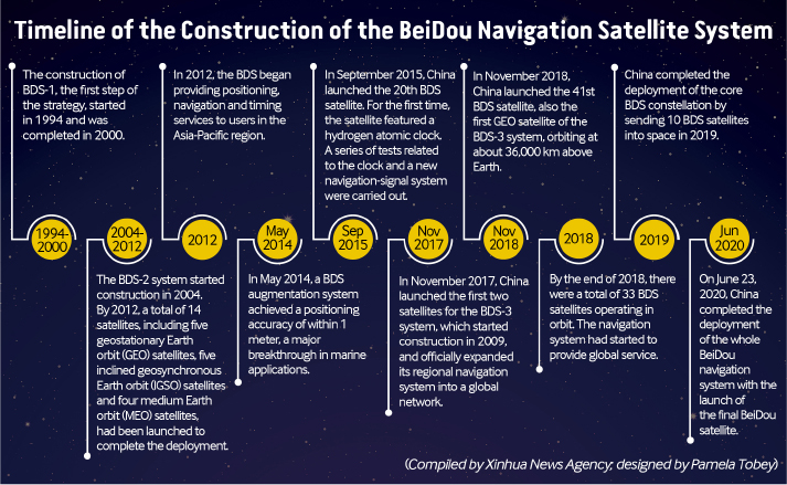
Three-step strategy The achievement has been made thanks to the efforts of generations of Chinese scientists for decades. Hundreds of thousands of Chinese scientists, engineers and technicians from research institutes, universities and enterprises have been involved in BeiDou's development. The roots of the system stretch back to the 1960s and 1970s when China started a project named the Lighthouse Plan to develop satellites for positioning and navigation. However, despite research and experiments, it did not come to fruition. At least four satellites are needed to provide precise geopositioning and China's economic power and technological strength at that time were insufficient to develop a satellite navigation system of its own. In 1983, space scientist Chen Fangyun proposed to develop a navigation satellite system with only two satellites and after strenuous theoretical and technological research, the blueprint for a two-satellite navigation system became clear. In the beginning, there were doubts whether it was necessary for China to build its own navigation satellite system. However, the need to lessen dependence on foreign navigation systems became urgent with the consideration that foreign countries providing the services can bar China or any other country from their signals any time if anything untoward happens. To better safeguard China's national sovereignty, security and development interests, it needed to develop its own satellite navigation system. There were also debates on whether China should build a global navigation system or a regional one. Sun Jiadong, chief designer of the first Chinese satellite, proposed a phased approach: developing regional service capacities first and then extending the services globally. In 1994, the BDS-1 system began to be developed. Between October 31 and December 21, 2000, two BeiDou navigation satellites were launched, making China the third country in the world to have its own satellite navigation system, following the U.S. and Russia. The BDS-1 had a unique feature—its short message communication service, which the others lacked. However, it was still not as effective as the others since it covered only China and surrounding areas. Also, as its orbit was higher than the GPS', its positioning was not as accurate. Therefore in 2004 work started on an upgraded version. For the BDS-2, the developers planned to import a core component—an atomic clock—from abroad. However, the attempt failed due to a technological blockade. Yang Changfeng, chief designer of the BDS, told Beijing-based People's Daily that the BDS-2 project had already started and without the core component, the whole system and the project would fail. So the team started developing an atomic clock on their own and it was ready in two years. Another problem arose. The most suitable radio frequencies for satellite navigation had already been bagged by the U.S. and Russia. China was assigned one by the International Telecommunication Union (ITU) on April 17, 2000 but with a string attached. The ITU stipulated that China would have to send a satellite into space within seven years to use the frequency. Since the BDS-2 project was started in 2004, it meant a satellite would have to be launched in three years, when normally it takes five years for one to be built and sent into orbit. The BeiDou team worked around the clock and in early April 2007, the first BDS-2 satellite was ready. However, during the last test before the launch, a problem was detected in the transponder on the satellite. To meet the ITU deadline, the problem had to be fixed within three days. But the manufacturer was in Shanghai in east China, and it was difficult to ship the transponder back and forth between the two places. The BeiDou team decided to ask another research institution in Chengdu, which was near the launch site in Xichang. Finally, the task was completed and the satellite was launched into space on April 17, with just four hours left before the seven-year deadline set by the ITU elapsed. By 2012, a total of 14 satellites—five geostationary Earth orbit satellites, five inclined geosynchronous orbit satellites and four medium Earth orbit satellites—were launched to complete the deployment of the BDS-2. A hybrid of satellites in three types of orbits is a unique feature of the BDS. With these satellites in space, the system began to provide users in the Asia-Pacific region with positioning, velocity measurement, timing and short message communication services. Development of the upgraded BDS-3 started in 2009. Traditionally, satellites are controlled from ground stations located around the world. However, as it was difficult to build ground stations everywhere, the mandate of the BDS-3 was to overcome this difficulty with cutting-edge space technology. In November 2017, the first two satellites for the BDS-3 system were launched and the regional navigation system expanded into a global network. As of the end of 2018, 33 BDS satellites were operating in orbit and the navigation system started to provide global services. The positioning accuracy of the system reached 10 meters globally and 5 meters in the Asia-Pacific region. Its velocity accuracy was 0.2 meter per second, while its time accuracy stood at 20 nanoseconds. The designed lifespan of BDS-3 satellites is 12 years, on par with advanced satellites elsewhere. In 2019, the deployment of the core BDS constellation was completed with 10 BDS satellites sent into space and networked. The BDS-3 is more advanced than the two previous versions. For instance, the short message communication capability has greatly improved, allowing longer and two-way messages to be sent. With the BDS-3, users in areas with poor conventional communication signals can send up to 1,200 Chinese characters in a single message, whereas previously, only 120 characters could be sent in a single message. They can also send images. Chi Jun, Chief Commander of the BDS-3, told Xinhua News Agency that it is an important infrastructure not only for China but for the whole world. Besides normal uses in agriculture, transport, weather forecasts and infrastructure development, BeiDou can be used for extraordinary missions like search and rescue operations. The system helps to pinpoint the locations of those in danger, who can send messages to ask for emergency help while rescuers can reply to boost their morale. During storms, even if conventional communication signals are unavailable, fishermen at sea can tell their families at home that they are safe via the BDS. Relevant departments can also warn them of potential dangers like imminent storms via the system. 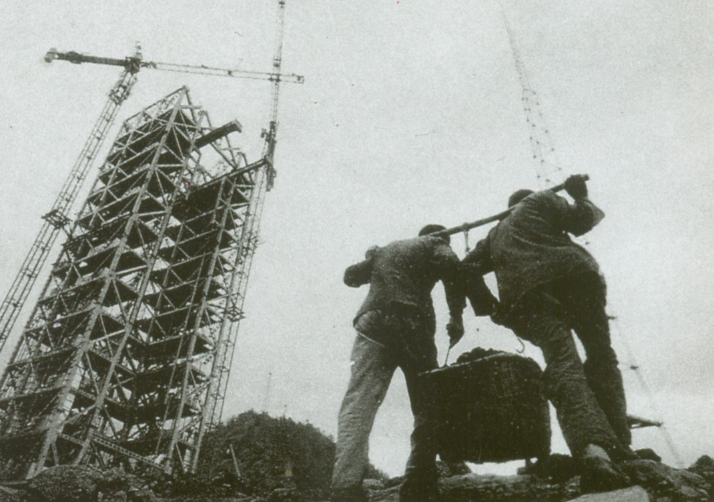 A launch tower under construction at the Xichang Satellite Launch Center in Sichuan in 1990 (XINHUA)
Serving the world The BDS is cooperating with the other global navigation systems. Ran Chengqi, Director of the China Satellite Navigation Office, told Xinhua collaboration among the four systems will provide more accurate and reliable navigation and positioning services for global users and promote interconnectivity between countries. The BDS has provided services to more than 500 million users in the world, including users in nearly 100 countries participating in the Belt and Road Initiative, namely the Silk Road Economic Belt and the 21st-Century Maritime Silk Road. Pakistan became the first foreign country to use the BDS, where the system was hailed especially for its role in strengthening the China-Pakistan Economic Corridor, a flagship project of the two neighboring countries under the Belt and Road Initiative, by providing remote-sensing information. The BDS is used in transportation in Pakistan, river transportation management in Myanmar, and agriculture in Laos. Currently over half of the countries in the world are using BDS services, which though created by China are shared with the world. Moreover, China is developing the Space Silk Road with Arab states, in which the BDS has a role to play. At the second China-Arab States BDS Cooperation Forum in Tunisia last year, officials, experts and business people from China and Arab countries discussed closer cooperation on a wider application of the BDS in the Middle East. "The BDS cooperation is the best example of the strategic cooperation between China and Arab states, as satellite navigation integrates many hi-tech areas, including telecommunication and space technologies," Slim Khalbous, Tunisian Minister of Higher Education and Scientific Research, said at the forum. "This is an important opportunity for Tunisia, while the BDS cooperation also means further upgrade of China-Arab relations," Khalbous told Xinhua.
(Printed Edition Title: Compass in the Sky) Copyedited by Sudeshna Sarkar Comments to jijing@bjreview.com |
|
||||||||||||||||||||||||||||||
|